


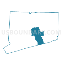
Middletown 10 Voting District, Middlesex County, Connecticut
About
Outline

Summary
| Unique Area Identifier | 549878 |
| Name | Middletown 10 Voting District |
| County | Middlesex County |
| State | Connecticut |
| Area (square miles) | 17.17 |
| Land Area (square miles) | 16.35 |
| Water Area (square miles) | 0.82 |
| % of Land Area | 95.22 |
| % of Water Area | 4.78 |
| Latitude of the Internal Point | 41.52300700 |
| Longtitude of the Internal Point | -72.58723460 |
Maps


Graphs
Select a template below for downloading or customizing gragh for Middletown 10 Voting District, Middlesex County, Connecticut


Neighbors
Neighoring Voting District (by Name) Neighboring Voting District on the Map
- Durham 2 Voting District, Middlesex County, CT
- East Hampton 1 Voting District, Middlesex County, CT
- Haddam 1 Voting District, Middlesex County, CT
- Haddam 3 Voting District, Middlesex County, CT
- Middlefield 1 Voting District, Middlesex County, CT
- Middletown 11 Voting District, Middlesex County, CT
- Middletown 13 Voting District, Middlesex County, CT
- Middletown 9 Voting District, Middlesex County, CT
- Portland 1 Voting District, Middlesex County, CT
Top 10 Neighboring County Subdivision (by Population) Neighboring County Subdivision on the Map
- Middletown town, Middlesex County, CT (47,648)
- East Hampton town, Middlesex County, CT (12,959)
- Portland town, Middlesex County, CT (9,508)
- Haddam town, Middlesex County, CT (8,346)
- Durham town, Middlesex County, CT (7,388)
- Middlefield town, Middlesex County, CT (4,425)
Top 10 Neighboring Place (by Population) Neighboring Place on the Map
- Middletown city, CT (47,648)
- Portland CDP, CT (5,862)
- Durham CDP, CT (2,933)
- Higganum CDP, CT (1,698)
Top 10 Neighboring Unified School District (by Population) Neighboring Unified School District on the Map
- Middletown School District, CT (47,648)
- Regional School District 17, CT (14,871)
- East Hampton School District, CT (12,959)
- Regional School District 13, CT (11,813)
- Portland School District, CT (9,508)
Top 10 Neighboring State Legislative District Lower Chamber (by Population) Neighboring State Legislative District Lower Chamber on the Map
- State House District 32, CT (24,842)
- State House District 36, CT (23,652)
- State House District 100, CT (23,554)
- State House District 34, CT (21,648)
Top 10 Neighboring State Legislative District Upper Chamber (by Population) Neighboring State Legislative District Upper Chamber on the Map
- State Senate District 9, CT (104,736)
- State Senate District 13, CT (101,659)
- State Senate District 33, CT (98,002)
- State Senate District 12, CT (96,990)
Top 10 Neighboring 111th Congressional District (by Population) Neighboring 111th Congressional District on the Map
- Congressional District 2, CT (729,771)
- Congressional District 3, CT (712,339)
- Congressional District 1, CT (710,951)
Top 10 Neighboring Census Tract (by Population) Neighboring Census Tract on the Map
- Census Tract 5901, Middlesex County, CT (8,346)
- Census Tract 5851, Middlesex County, CT (7,388)
- Census Tract 6802, Middlesex County, CT (6,726)
- Census Tract 5601, Middlesex County, CT (5,816)
- Census Tract 5420, Middlesex County, CT (4,439)
- Census Tract 5801, Middlesex County, CT (4,425)
- Census Tract 5602, Middlesex County, CT (3,692)
- Census Tract 5502.02, Middlesex County, CT (3,176)
- Census Tract 5422, Middlesex County, CT (1,638)
Top 10 Neighboring 5-Digit ZIP Code Tabulation Area (by Population) Neighboring 5-Digit ZIP Code Tabulation Area on the Map
- 06457, CT (47,648)
- 06424, CT (12,808)
- 06480, CT (9,508)
- 06422, CT (7,388)
- 06441, CT (5,438)
- 06455, CT (3,148)
- 06456, CT (295)